
Iceland Lab’ - 15th to 29th July 2018
Iceland Lab’ - 15th to 29th july 2018
IceLand Lab’ 2018 - 15th to 29th July 201 18 European teenagers decided to discover the mysteries of Iceland through a two weeks scientific holiday.
13-15 ans ; 16-18 ans ; Adultes Lieu : Islande Domaines : Séjour Linguistique, Volcans, Géologie, Journalisme Scientifique, Glaciers, Changement climatique,
By Thor and Odin ! We come to you, young explorers, to tell you about the adventure you are about to live ! You will not believe your eyes : volcanoes, fjords, geysers, waterfalls, Hot pods and abyssal rocks, will arise from all sides, just like this island emerging from below water. But Iceland is not just about such geological curiosities, it’s also a mountain with Elves *, 6-speed horses * and religious birds *, as well as exotic plants able to populate an inhospitable environment.
- Dear parents, please do not worry about your (...)
- FINAL PROJECT
- Day 1 - Sunday July 15th 2018
- Day 2 - Monday July 16th 2018
- Day 3 - Tuesday July 17th
- Day 4 - Wednesday July 18th 2018
- Day 5 - Thursday July 19th 2018
- Day 6 - Friday July 20th 2018
- Day 7 - Saturday July 21st 2018
- Day 8 - Sunday July 22nd
- Day 9 - Monday July 23rd 2018
- Day 10 - Tuesday July 24th 2018
- Day 11, 12 and 13 - July 25th to 27th (...)
- Day 14 - Saturday July 28th 2018
And if you get a bit deeper, you will surely find more wonders, yourself to discover... We will be working during that camp on the exceptional events currently happening in Hawaii ! Get up to speed if you do not follow already : https://volcanoes.usgs.gov/observat... (Update -> MultiMedia) http://www.bigislandvideonews.com/ (from may 15th 2018) But where does this island come from : https://www.youtube.com/watch?v=MhL... Many explorers and young scientists came before you ! They left you reports to better prepare you for your expedition. In French : www.osi-mineo.org/Courts-metrages-I... In English : www.osi-mineo.org/Courts-metrages-I... See you soon on the ground of your adventure !
Dear parents, please do not worry about your kids, they are all fine, happy, and enjoying their holiday. To be honest they don’t think about you at all. You will have news through that website almost every day
FINAL PROJECT
Day 1 - Sunday July 15th 2018
We landed in Iceland after an exhaustive flight. We easily located the other campers because of the crowd of people gathered around a computer to watch the world cup Final. The Icelandic onlookers marveled at the noisy group with French flags painted onto their faces. When we had finished celebrating France’s win in the world cup, we grouped onto mini vans for the hour-long trip to our camp site. On our arrival we looked onto the small field that would be our homes for the next few nights. The counselors handed us tents and we learned to set them up through trial and error. We gathered together in the communal dinner tent for a hearty dinner of tomatoes and pasta and once we cleaned our plates we then retired to our tents for our first night in Iceland.
Day 2 - Monday July 16th 2018
On day 2 we woke up and had breakfast. After taking care of the dishes and cleaning the table. We had a long conference where we made up our own rules of the society we were going to form during our expedition. We also decided groups for cooking, cleaning and research that switch everyday. In the afternoon, we went on a long journey in the mountain, where we got to a river that was heated naturally.
With the help of a laser powered thermometer we analyzed the temperatures found at different locations of the hot spring. Up stream : 64°02’55,3’’N21°13’23.9”W Time : 16:47 39.6 °C Down stream : Time : 17:05 30.6°C To sum up the data, the temperature at the highest accessible point was 9 degrees higher then the lowest accessible point in the river.
It can be inferred that the water cools off further down stream as it is exposed to the colder outside air. Hot spring #2 : Coordinates : 66°02’46N 21°13’19.3W Time : 17:10 88 °C We learned that the temperature of these hot springs is so high because water deep in the soil is heated by the magma and is turned into steam which makes its way up to the surface in the form of these springs.
Once we arrived at the camp, the cooking team could be audibly heard struggling as their tent threatened to implode and the team in charge of the journal came up with the idea for today’s journal.
Day 3 - Tuesday July 17th
In the morning, we woke up early and we went to the famous Golden Circle. First, after one hour of driving, we arrived at the Icelandic rift. It is the place where the American and European tectonic plates separate. The rift grows 2cm per year. 20 million years ago, Iceland was created because it is over a hot spot and 2 tectonic plates. It’s the only places on earth where you can walk on the oceanic plate. There is a church on the rift near where Icelanders held Parliament. Here, they debated the laws and held trials.
Many people where beheaded, hung, burned and drowned from 1602 and 1750. Many women were accused of witchcraft. Vengeance was recurring. After lunch we saw the geyser Stokkùr. At the bottom of the column, the water is hot. The bubbles of gas rise and grow where the column is narrow then the bubbles get stuck and pressure rises. When the pressure is to high the water boils and the geyser erupts.
This cascade is a unique natural phenomenon that triggers varying impressions to people. No waterfall in Europe can match Gulfoss. She’s wild like a tiger and soft like a flower pot.
Day 4 - Wednesday July 18th 2018
The visit of Hellisheidi’s power plant and his museum : At first, the hot springs were considered dangerous by humans. Over the time they contributed to every day’s life using like baptism, heated water, bath, cure, cook, salt extraction, agriculture… Now, since the oil crisis in 1970, the geothermal energy reached up to 26% of the Iceland electricity production. The use of geothermal energy in Iceland is very important. 90% of the houses are warmed this way and it reaches 99.9% in Reykjavik.
A geothermal power plant is a factory which uses the geothermic energy to produces electricity and hot water for consumers. The site is composed of a main building that contains turbines and generators. Close by, can be found the pumping stations. Fluid comes to the factory using big curved pipelines. It brings flexibility to the tubes in case of earthquakes, it also protects them from the expansion and the contraction caused by the climate variations.
The energy is provided by a drilling that extracts fluid (300°C) from the deep ground (2000-3000 meters) then, the fluid is separated in two parts : steam and hot water. The steam goes through a turbine which activate a generator and make electricity. The hot water goes in another part and warms potable water for the population.
This central produce 30% of all the geothermic energy produced in Iceland
The visit of the crystal museum :
We visited a little exhibition of crystals and volcanic stones which have been collected by the guide’s family. The man was fascinated by hiking and collecting rocks : he learned by his own the geology while reading books. He explained us how find these different stones and their origins. Some of them comes from Hekla, a volcano in east Iceland. We saw different erupted materials like tephra or pumice (ponce) and obsidian (volcanic glass). In this exhibition we saw a vast collection of crystals which are found in the isle like geodes, sulfur, calcite, amethyst and even few fossils. In the center of the room there was the biggest piece of petrified wood of Iceland. It makes when a tree is covered by sediments which conserved it, with time the wood became stone.
To end the day, we went to the Selfoss’s swimming pool heated by the geothermal activity, this allows the use of 40-42°C water. Into the swimming pool, there was a lot of different pool (4°C, 40°C-42°C, 35°C, indoor…) but the more unusual thing was the nudity in the dressing room and in the shower.
Day 5 - Thursday July 19th 2018
Today we set off for the longest hike of the trip. After eating breakfast and having our daily forum we encountered slight technical problems with the red car that were quickly resolved. Then, we began the two-and-a-half-hour car trip to the hiking spot. Most of us dozed off easily but we were all suddenly woken up by the transition onto the much steeper and very bumpy gravel road. As heads bumped back and forth against headrests our vans flitted by a landscape of bare valleys and vast mountains.
 At our arrival at the base of the trails, we looked over maps and were given the information that the hike we’d be doing lasted five hours and covered twenty-four km. We started our ascent with a steep hill that opened onto a flat plain made of volcanic rock. The ground was littered with pumice and obsidian rocks of varying sizes.
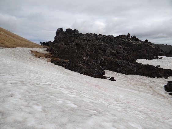 As we departed from the dark surroundings we were greeted first by the putrid smell of thermal pools and then by the imposing mountain ranges spotted at the peaks with everlasting snow.
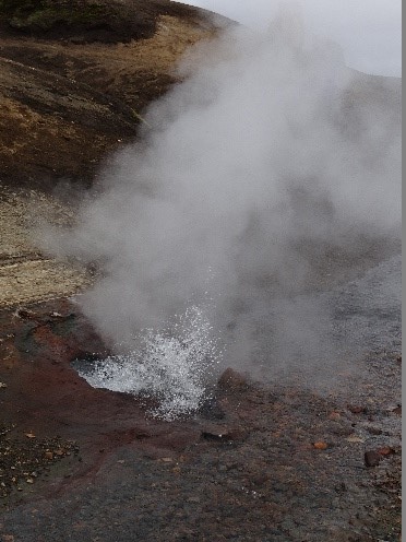 As we trekked our way up the side of a hill the first deep breaths could be heard. At the summit of the hill it was inquired what was the distance we’d covered was and were astounded to hear we’d only worked through three km. Only an eighth of the hike !
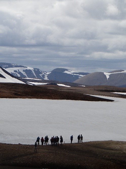 When we arrived at a flat mountaintop we took food out of our bags and feasted on the well-deserved meal.
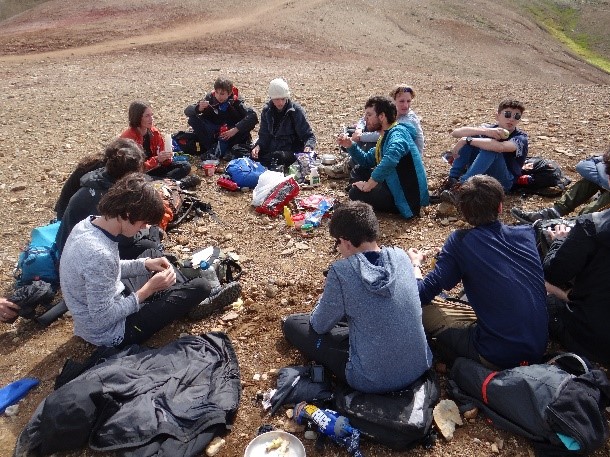 Once fueled we observed the clay on the ground and how it changed colors from red to orange, to white, and even purple ! After we took a group photo we carried on with the hike.
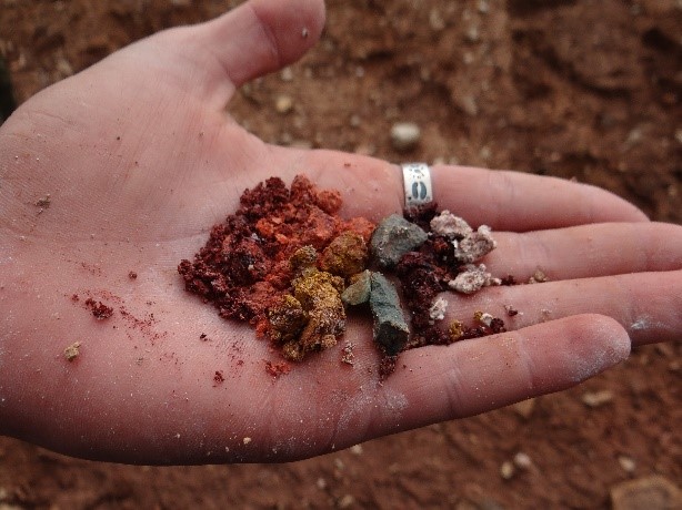 It seemed like the farther we went, the steeper the hike would get, and the deeper the holes you’d fall in if you didn’t pay attention got. As we got to a certain point on the trail we all stopped to take a decision. It was getting late and we still had a part we could hike. Out of water, food and energy we decided to head back. As we got to a steep incline covered with snow that we had just climbed we observed people slide down the hill, sometimes tumbling down. We shared some good times and laughs. An hour later, as our feet were aching, we noticed the group got quieter and wasn’t as energetic as before. After what had seemed like a while we finally gazed over the campsite where we had started off. We were all so tired we fell to the ground as if a force was dragging us down. We filled up our empty water bottles and got in the cars for the long ride home. The ride consisted of naps and chill music. For those who were awake we reminisced on the stunning glaciers, geysers, and endless landscapes.
Day 6 - Friday July 20th 2018
This morning we packed up our stuff, folded up the tents and left. We drove for half an hour and we arrived at the Lava centre. Here is what we discovered : Iceland is the largest island on the Mid Atlantic Ridge. It has been built up by rising magma from a powerful mantle plume and magma emerging between two diverging tectonic plates. The mantle plume is a specific area on earth where a large column of magma rises from deep underground. It consists of molten rock around 100-700 km large.
There are 30 active volcanoes on the island and they are all different depending on their location. Volcanoes under the sea : the magma rises from the chamber and forms lava pillows as the pressure is high. Because of the volcano rising, the pressure lowers, and the eruption becomes more explosive, forming breccia. The breccia consists of glassy fragments and pieces of lava. When the volcano comes out from the water there is no longer any pressure. So tephra starts to fall. (underwater volcano in Iceland : Sustey 1963-1967) Volcanoes on earth : The temperature influences the type of eruption. 750°C : The explosion comes from the magma chamber which is under the earth. Fluids and gasses do not escape easily. It is an explosive eruption so there is a lot of tephra and ash. 950°C : When the lava has this temperature, the eruption is not very explosive. There is a lot of rough lava and tephra (volcano on land in Iceland : Fimmördufàlo 2010) 1150°C : The eruption comes from the magma source area. The magma is very hot and fluid and gasses escape easily. The eruption is not explosive and lasts a long time. There is no tephra. (volcano on land in Iceland : Bàrdarbunga 2015) Volcanoes under glaciers : There is a large volume of ice that melts above the vent. Melted water starts flowing and ice cauldron forms on the surface. Water bursts out from the edge of the glacier and exports and erodes sediments. That creates a sand plain. (volcano under glaciers in Iceland : Myrdalssandur) Volcanoes that come from fissures : The magma is more liquid because it is arriving from deeper down. It flows from the fissures created by the earthquakes. (Volcano that come from fissures : Laki 1783, during 9 months, the lava expanded for 25km) Stratovolcanoes : They are high cone-shaped mountains. There is a central vent, but later fissures or lateral vents can appear on the volcano cone. Eruptions are explosive and lava is viscous. Tephra and lava accumulates around the vent. That is how they get bigger. (stratovolcanoes in Iceland : Oraefajökull, Snaefellsjokull). Volcanoes in calderas : They have a large magma pocket. The chamber feeds several vents or fissures in various and closes places. When the magma chamber empties a depression is created and the subsidence of rocks above creates the caldera. Every day, there are earthquakes in Iceland that come from the energy suddenly released from the stress built up through diverging tectonic plates.
Day 7 - Saturday July 21st 2018
After a wet night in the city of Vik (which means wind in Icelandic), we discovered the black sand beach and its puffins. As its name indicates, this beach is largely composed of volcanic rocks which contrast with the traditional white sandy beaches. On the cliffs we were able to see a lot of puffins nestled on basalt formations. This strange bird is the animal that symbolizes the Icelandic folk. It was impressive to see them jump in the air and fly over our heads.
On the other side of the mountain, we saw a typical lava rock formation : the basalt columns. The fast cooling on the surface makes the rocks shrink, creating hexagonal fractures that propagate vertically, making basalt columns. Thanks to the weathering, a cave has been created just under the mountain. Making a beautiful point of view of the bottom of the columns.
After a while we drove to Laki volcanic lava flow, an eruption which took place in 1783. This fissure eruption of very liquid lava named “Pahoehoe” flowed over a huge surface. And this super eruption also rejected tons of gas and ashes that provoked multiple starvations all over the North hemisphere. For example, it caused the worst Japanese starvation that killed more than a million people, and in France it caused the revolution of 1789 creating one of the biggest democracy of the world (we are the champions). We can’t imagine that such a common place in remote Iceland had so many worldwide consequences.
Day 8 - Sunday July 22nd
Today we woke up as usual at 8 am, had a breakfast of Skyr and off brand Nutella toasts then gathered together for the daily forum. During the forum, we talked about the hike at the national park of Vatnajokulspjordur where we would be hiking a trail overlooking a glacier. We packed our bags for the long hike awaiting us which totaled 16 km. We loaded our packs into the car and drove to the bottom of the trailhead.
Once we arrived, we unloaded our bags and formed a circle to stretch and get warmed up for the hike ahead of us. The first hour of the hike was in a narrow trail surrounded by greenery and the occasional river crossing, to the right the trail dropped off and we could see the glacier and the flat plains surrounding us.
Slowly, the trail widened until we reached the first mountain peak. There, breathing heavily and a little sweaty, we dropped off our bags and sat down. Karol taught us about the different types of glaciers and their properties. The glacier we could see from the trail was an outlet glacier which means that it descends from an icecap. We also learned the two main parts of a glacier, the accumulation zone where snow piles on top of itself and compacts to add onto the glacier and the ablation zone where the glacier melts. Glaciers can either advance or melt away and a tool used to find this out is to take a picture of the glacier at the same location and the same period of the year every year to see the differences. So, to figure out how the glacier in front of us was moving we partook in an activity where we tried to find the mark left years ago on a rock by a previous O.S.I. expedition so we could reposition the camera in the same spot the groups in years before had.
We then ate lunch and continued the hike. During the second part of the hike, the terrain was more open, but we stopped several times. After a long ascension, we decided to take the shorter of two hiking paths because the weather had become very cloudy and everyone was running low on water. The way back lasted 10 km and we barely took any breaks except one to eat a quick snack of cookies. The final view we had during the hike was a hidden cascading waterfall. Once we arrived at the parking lot we all collapsed into the vans before driving back to the camp site.
Day 9 - Monday July 23rd 2018
Today we started the day with the forum and an introduction to the new projects. During this new week, we will work in groups on different scientific topics that we already discovered last week. For example, we could have chosen a subject such as glaciers, volcanism, geothermal activity or tectonic plates. Those projects will end up with the realization of a video or an article. We left the camp to find a thermometer that was installed by the group from last year. Unfortunately, we finally didn’t find it ! It wasn’t where they left it… we believe it has been stolen.
After lunch, we went to Jokulsarlon, a place where an outlet glacier from the Vatnajokull ice cap melts and make icebergs when a part of ice separates from the glacier. The icebergs travel through the lake and enter in the sea.
We learned that for an iceberg, one third of the volume is above water and two thirds below. Then, we had free time to enjoy the glacier and the beach. Later, we walked on a path next to another glacier. We stopped to observe and listen to it. The glacier always moves downhill and when some ice breaks apart it makes a loud and deep cracking noise. With luck and silence some of us were able to hear it.
Also, we could see that the rocks and boulders outcrop were covered in scratches or striations : those are due to rock debris that get stuck under the bottom of the glacier as it creeps forward. There are two kinds of ice that forms the glacier : the white ice, which is young and filled up with a lot of bubbles hence its colour and the blue ice, which is old and denser because it has been compacted under other ice. Finally, we came back to the camp and had a very good diner.
Day 10 - Tuesday July 24th 2018
Today, we left the Svinafell camping to return to Hveragerdi so it wasn’t a very interesting day, even if we stopped at Skogafoss, a very popular waterfall. It was impressive because we could climb on a stair that was on the border of the waterfall, allowing us to observe the water from different viewpoints.
During the evening in Hveragerdi’s campsite we started to think about our projects which concern different topics : volcanism, glaciers, tectonic plates, geothermal energy and crystal formations. We will try to find for each of this topic a problematic and discuss it.
Day 11, 12 and 13 - July 25th to 27th 2018
The participants each chose a problematic and gathered in groups. They worked during those three days on their project, and prepared a retransmission in the form of a short movie.
The different groups and themes were :
![]() Crystal formation, by Victor and Swan
Crystal formation, by Victor and Swan
![]() Geothermal energy by Bernat and Nathan
Geothermal energy by Bernat and Nathan
![]() Tectonic plates by Pauline and Antoine
Tectonic plates by Pauline and Antoine
![]() Glaciers by Louis, Florian, Gabriel and Eliot
Glaciers by Louis, Florian, Gabriel and Eliot
![]() Prediction of volcanic eruptions by April and Auxane
Prediction of volcanic eruptions by April and Auxane
![]() Volcanoes and men, by Arthur, Louis, Victor and Erwan
Volcanoes and men, by Arthur, Louis, Victor and Erwan
Day 14 - Saturday July 28th 2018
Visit of a lava tube in the morning, then return to Reykjavik in the afternoon, for a tour downtown. Short night close to the airport before the participants left on Sunday.
, , , ,
date de publication : 9 juillet 2018,
date de dernière mise à jour : 10 décembre 2018
Soutenez l'association en partageant cette page autour de vous :


